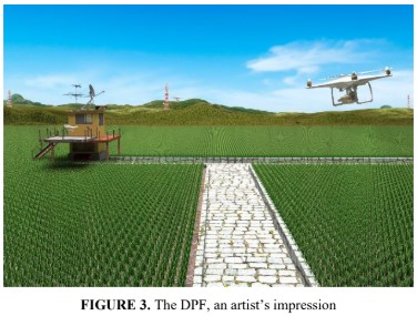
Drone for Precision Farming (DPF): Conceptual Design, System Integration, and its Preliminary Outcomes
 Author: Gunawan Setyo Prabowo1, Adi Wirawan, Lidia Pandjaitan, Try Kusuma Wardana, Yanuar Firmansyah, Abdul Aziz, Bambang H. Trisasongko, Dyah R. Panuju, Desi Nadalia, Nur Etika Karyati, and Rizqi I’anatus Sholihah
Abstract: Agriculture has been one of the prominent issues for many countries. The ability to secure food supply drives research and development in a diverse domain. With its nature, agricultural monitoring should be investigated in a spatial context. It allows a more precise measurement in terms of area or in other spatial entities. Satellite-borne sensors have been in extensive use. Nonetheless, high-fidelity remote sensing data are required for small land parcels in Indonesia and comparably developing countries. With the cost associated with data acquisition and the complexity of the procedure, alternatives should be sought. In this decade, the development of drones (unmanned aerial vehicles, UAVs) has made substantial progress, making them suitable for monitoring food estates. However, this involves a complex system, not only the drone system itself. Additional supporting systems, such as data center, big data construction and manipulation, information extraction (especially using machine learning) and manpower have long been understood as the core issues. This article briefly discusses a proposed Indonesian drone system with its associated tools as the interface to food estate management. System design, data center, and some preliminary works focusing on Indonesian key areas for red onions are briefly presented.
Proceeding URL: https://pubs.aip.org/aip/acp/article-abstract/2957/1/030001/3261977/Drone-for-precision-farming-DPF-Conceptual-design?redirectedFrom=PDF

 Indonesia