
 Indonesia
Identifying the Driving Forces of Urban Expansion and Its Environmental Impact in Jakarta-Bandung Mega Urban Region
Pusat Teknologi Satelit LAPAN dan Institut Pertanian Bogor menyelenggarakan konferensi internasional “The 4th International Symposium on LAPAN-IPB Satellite (LISAT)” pada tanggal 9-11 Oktober 2017. Konferensi ini dilaksanakan di IPB International Convention Center, Bogor dengan tema “The Role of Satellite Technology for Food Security and Environmental Management”. Pusat Pengkajian Perencanaan dan Pengembangan Wilayah (P4W) ikut berpartisipasi dalam kegiatan konferensi internasional tersebut dengan memaparkan paper hasil penelitian terkait topik Environmental Management dengan judul “Identifying the Driving Forces of Urban Expansion and its Environmental Impact in Jakarta-Bandung Mega Urban Region”. Paper tersebut ditulis oleh Dr. Andrea Emma Pravitasari; Dr. Ernan Rustiadi; Setyardi Pratika Mulya, S.P., M.Si.; Dr. Yudi Setiawan; Lutfia Nursetya Fuadina, S.P. dan Alfin Murtadho, S.P. Paper ini akan segera diterbitkan dalam prosiding IOP Conference Series: Earth and Environmental Science dimana saat ini paper telah selesai dalam tahap proses review. Berikut merupakan bagian dari abstrak paper.
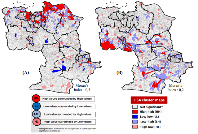
The socio-economic development in Jakarta-Bandung Mega Urban Region (JBMUR) caused the increasing of urban expansion and led to a variety of environmental damage such as uncontrolled land use conversion and raising anthropogenic disaster. The objectives of this study are: (1) to identify the driving forces of urban expansion that occurs on JBMUR and (2) to analyze the environmental quality decline on JBMUR by producing time series spatial distribution map and spatial autocorrelation of floods and landslide as the proxy of anthropogenic disaster. The driving forces of urban expansion in this study were identified by employing Geographically Weighted Regression (GWR) model using 6 (six) independent variables, namely: population density, percentage of agricultural land, distance to the center of capital city/municipality, percentage of household who works in agricultural sector, distance to the provincial road, and distance to the local road.